[[[SUMMARY_START]]]
Lava from Piton de la Fournaise on Réunion Island has reached the Indian Ocean after a long eruption that began in mid-February. The flows crossed part of the RN2 coastal road and prompted safety restrictions on land and at sea. Officials kept exclusion zones in place as the volcano continued to send lava downslope.
[[[SUMMARY_END]]]
Lava from Piton de la Fournaise, one of the world’s most active volcanoes, has reached the Indian Ocean on Réunion Island after an eruption that began on February 13. The event followed weeks of steady lava movement across the Grand Brûlé slopes, where several flows cut the RN2 coastal road and moved toward the shoreline. Local authorities tightened safety measures as the meeting of lava and seawater created new risks near the coast.
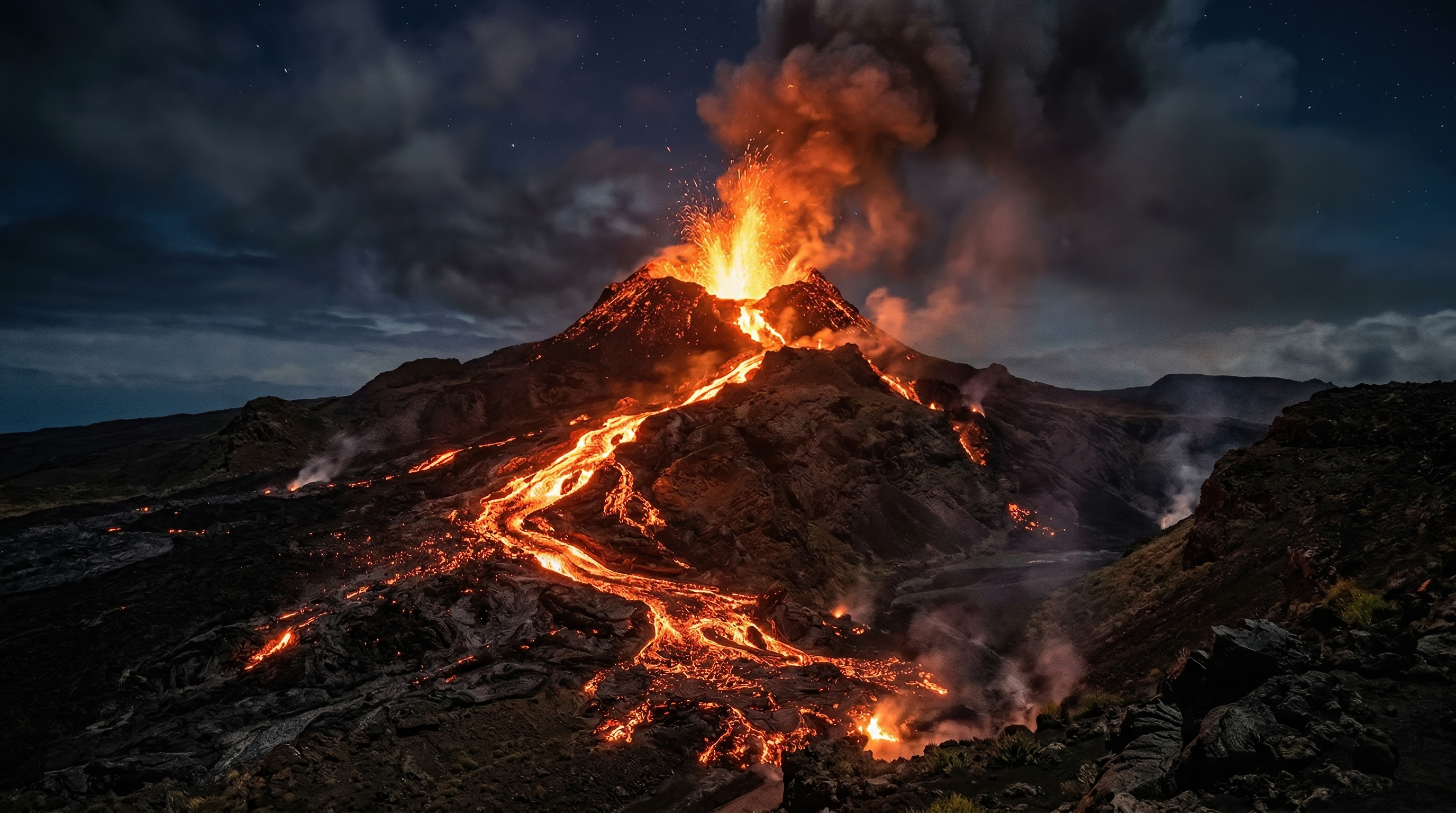
Réunion Island’s latest volcanic eruption has produced one of the most striking outcomes seen on the island: lava entering the sea.The eruption at Piton de la Fournaise began on February 13, 2026, and continued through March, sending several lava flows down the volcano’s southeastern flank. Over time, the flows advanced across the Grand Brûlé area, a sparsely populated zone that has often carried lava during past eruptions.
By mid-March, the most advanced fronts had already crossed sections of the RN2, the main coastal road that links communities in the island’s southeast. Officials warned that the movement of lava could change quickly, with pauses followed by sudden advances. They also expanded security perimeters as new branches of lava appeared and threatened to cut off areas near the road.
## Lava reaches the Indian Ocean
The lava reached the ocean around the middle of March, ending days of close monitoring along the coast. When molten rock met seawater, it created large white steam plumes and a hazardous shoreline environment. That contact can cause unstable ground, sudden collapses at the edge of new lava deltas, and exposure to volcanic gases and acidic steam.
Authorities responded by restricting access not only on land but also offshore. A temporary no-go zone was set up in coastal waters near the entry point, covering navigation, anchoring, water sports and fishing. The measures were designed to reduce the risk to sightseers, boat operators and fishers drawn to the unusual spectacle.
Health officials had already warned residents about volcanic fallout linked to the eruption, including fine strands of volcanic glass known as Pele’s hair. Air quality also remained a concern in some areas because active eruptions can release gases and particles that travel with the wind.
## Road disruption and public safety concerns
Officials kept strict controls on movement near the site. Turnaround points for vehicles were set up on either side of the damaged area, while access beyond some barriers was limited to pedestrians and cyclists in designated sections. Drone flights were also banned in the area during part of the response, reflecting both aviation safety concerns and the need to avoid interference with monitoring and emergency operations.
At times, the danger was not limited to the main flow itself. On April 1, authorities warned that a newly active branch south of the existing cut could cross the RN2 at very short notice, creating a serious risk of trapping people who had moved beyond security barriers. Heavy rain and thunderstorms added to the uncertainty, making the terrain more difficult and the situation harder to predict.
## A familiar pattern on a highly active volcano
Piton de la Fournaise is well known for frequent eruptions, though not every event sends lava all the way to the coast. The volcano rises from an uninhabited enclosure that helps limit direct damage to towns, but coastal roads and access routes remain exposed when flows travel far enough downslope.
Lava entering the sea is rare enough to draw wide attention, yet it is not without precedent on Réunion. A major eruption in 2007 also sent lava across the same coastal sector and into the ocean, changing the shoreline and damaging infrastructure. The 2026 eruption has revived memories of that event while again showing how quickly the volcano can reshape the island’s landscape.
For scientists, the eruption is another reminder of Piton de la Fournaise’s steady power and close watchfulness. For residents and visitors, it has been both a dramatic natural display and a practical test of road access, safety rules and patience around a volcano that remains active.
AI Perspective
This eruption shows how a volcano can be both a natural wonder and a public safety challenge at the same time. On Réunion Island, the most dramatic images came with real risks for roads, air quality and coastal access. The event is also a reminder that even familiar volcanoes can change local conditions very quickly.


-134c72da.webp)


-6c40e5ef.webp)